Fort Worth District
Lakes and Recreation Menu
Waco Lake
The Waco Lake project was constructed by the U.S. Army Corps of Engineers, and is being operated under the immediate supervision of the District Engineer, Fort Worth District.
The project is located in the southeastern portion of the Bosque River Watershed, Brazos River Basin, entirely within McLennan County, Texas and to the north and west of the city of Waco, Texas.
The Waco Lake was authorized for construction under the Flood Control Act approved 3 September 1954. Construction of this lake began in June 1958, and deliberate impoundment of water began February 1965.
The Dam
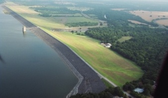
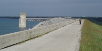
The dam is an earthfill embankment, with a concrete outlet works located in the upstream side and a concrete gate-controled spillway located in the left abutment. The overall length of the dam, including the spillway, is 24,618 feet. its maximum height is 140 feet above the streambed. The dam is constructed of selected soils, carefully placed and compacted. Twenty-four inches of riprap placed on the upstream face protects it from wave action.
The Purpose
Flood Control
The project provides 553,300 acre-feet of storage capacity for flood control of water between the top of the conservation pool, elevation 462' and the top of the gates, elevation 503'. This available storage space will provide reasonable control of the maximum flood record originating in the watershed.
Conservation
The portion of the lake allocated to conservation will be capable of storing 104,100 acre-feet of water at conservation pool level for municipal and other beneficial uses. The City of Waco exchanged storage in its old lake for an equivalent amount of conservation storage space in the new lake.The Brazos River Authority, a duly authorized State agency, has agreed to pay for the remaining space allocated to conservation storage and has contracted with the city of Waco for joint use of this space, with the city ultimately to the right to all of the conservation water.
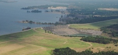
The Spillway
The spillway consists of an ogee gate controlled reinforced concrete weir. Its crest base for minimum water flow is at elevation 465 (mean sea level) and is 560 net feet in length. Fourteen tainter gates, each 40 feet wide and 35 feet high, are mounted on the crest.
The Outlet Works
The outlet works consists of a reinforced concrete structure located on the upstream side of the dam, with a 20-foot diameter conduit passing under the dam.
Extra Dividends
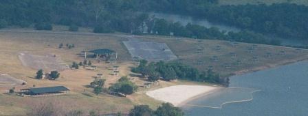
Recreation, favorable fish and wildlife habitats are "Extra Dividends" derived from this project and others like it built and operated by the Corps of Engineers in Texas. In cooperation with interested local, State and Federal agencies, the Corps of Engineers encourages the development of the "Extra Dividends" for the health and enjoyment of the visiting public.With the lake lands open to all, there are many attractive areas for outdoor recreation, water sports, hunting, fishing, boating, or just relaxed living.
Active Cooperation Built Waco Lake
The flood threat to the city of Waco and downstream portions of the Brazos - combined with the need for conservation storage to save millions of gallons of water that were wasted, -led local citizens to seek a new reservoir. Through their efforts, Congress authorized the project for construction by the Corps of Engineers.
By law, local interests are required to bear the cost of acquisition of the storage allocated to conservation in the reservoir. A water conservation contract covering repayment of the cost of those features has been approved, and, under its terms, the Brazos River Authority will also contribute its share annually for operation and maintenance of the project.
Waco Lake is operated for its various purposes by the Corps of Engineers, with water being furnished to the Authority under the term by the Texas Water Commission.
The Lake Fluctuates
The water surface level will be maintained at elevation 462 as much of the time as possible; however, this level is subject to fluctuation upward when flood waters are stored, or downward, depending upon the withdrawals for water supply from the conservation storage. During flooding over 3 feet above normal, some or all recreational areas may be closed.