Fort Worth District
Lakes and Recreation Menu
History of Benbrook Lake
Development of Benbrook Lake
Significant flooding on the Trinity River during May 1908, April 1922 and September 1936, was a primary cause for the development of Corps of Engineers flood control projects in North Texas.Benbrook Dam and Lake were built by the Galveston District of the Corps of Engineers, a division of the War Department, as the Department of Defense was known at the time. During the decade of active civil works construction that followed the Second World War, the U.S. Congress provided for the construction of Benbrook Lake, Grapevine Lake , Lavon Lake and Ray Roberts Lake as well as modifications to the existing Garza Dam for the construction of Lewisville Lake . The River & Harbors Act of 1945 authorized these projects for the purposes of both flood control and navigation. These lakes and others, along with an extensive floodway system of levees, are operated in a coordinated manner to minimize flooding along the Trinity River floodplain corridor in the Fort Worth and Dallas metroplex.
A second major influence for development was the desire of commercial interests for a shipping channel along the length of the Trinity River. This project, in its most grandiose design, was envisioned as a nine foot deep by 150-foot wide canal running upstream from Trinity Bay on the Gulf Coast to Dallas, and west all the way to Fort Worth. Downstream it would connect to the Houston Ship Channel. Twenty-six separate lock and dam projects were to be constructed. Today a ship channel is maintained upriver as far as river-mile 41 near Liberty, Texas. Although unlikely, if economic conditions were ever to make construction justifiable, a navigation channel linking Fort Worth to the Gulf of Mexico could still become a reality.
Water originally intended for use in this navigation channel was only recently re-allocated for municipal water use. The Tarrant Regional Water District in 1992 gained these water rights and now provides water supply to the cities of Benbrook, Fort Worth and Weatherford. The Water District has also built pipelines that connect Benbrook Lake with the Fort Worth’s Rolling Hills water plant and both Cedar Creek and Richland-Chambers reservoirs southeast of Dallas.
Construction of Benbrook Lake
Construction on the lake began in May 1947, and was practically completed when floodgates were closed and deliberate impoundment was begun in September 1952. The cost to build the lake was $14.5 million. The rolled-earth embankment is 9,130 feet in length, including the concrete spillway, and rises 130 feet above the streambed to an elevation of 747 feet above sea level. A pair of 6.5 by 13-foot sliding gates operated by electric cable hoists controls the floodwater releases through the 13-foot diameter conduit. Two 30-inch diameter pipes are provided for low-flow releases to maintain downstream river flows. The concrete spillway for uncontrolled releases is 500 feet long, with a 100-foot notch in its center.
At the normal, or conservation pool, level of 694 feet above sea level, the lake covers 3,770 surface acres. This would increase to 7,630 acres if the lake ever reaches the nominal maximum flood pool elevation of 724, which is also the overall spillway elevation at the top of the center notch.
One design option considered during the planning stages for the lake included an alternate damsite near the current I-20 bridge over the Trinity River, 3.7 miles downstream from the final, chosen location.
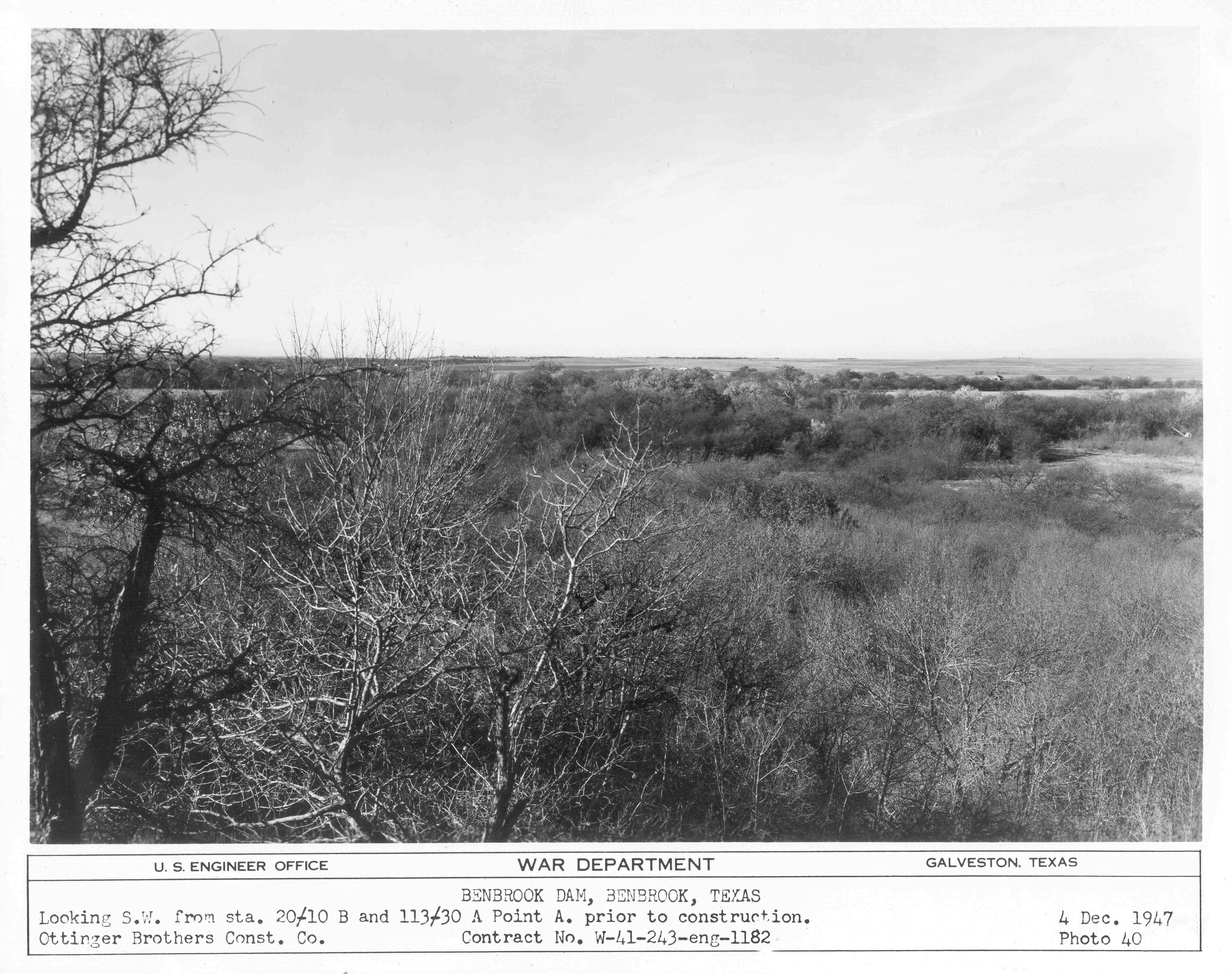
There was much more to construction than "simply" building the dam. Several railroads, roads and bridges, utility lines and cemeteries were relocated. The largest of these jobs was the re-routing of six miles of the Gulf, Colorado and Santa Fe Railway. Gravesites from seven separate cemeteries were relocated to the Benbrook municipal cemetery at Winscott and Mercedes. No significant cultural, archeological or paleontological features existed in the project area, according to the July 1948 pre-construction survey.
Flooding and operational history
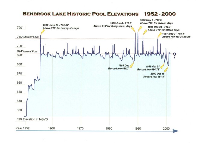
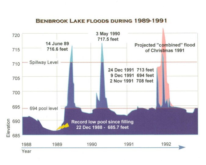
Flooding in May of 1949 claimed eleven lives in Fort Worth and cost $11 million to local businesses, as construction for the dam was beginning. During a spring 1957 flood, the new lake and the downtown floodway prevented $9.3 million in damages, almost recouping the original construction costs of the lake. During this flood, the lake filled to its 694-foot conservation level for the first time on May 12, 1957; the spillway elevation of 710 was reached on May 26 that year, with a record pool of 713.35 on June 6, 1957. This elevation was a record that lasted thirty-two years, but was then surpassed twice in an eleven-month period from June 1989 to May 1990. The current record pool level is 717.5 feet above sea level and occurred on May 3, 1990. Flood damages prevented by Benbrook Lake from 1989 through 1991 have pushed the total savings for the life of the lake to over one billion dollars. When holding floodwaters, the lake pool rises above the normal elevation of 694 feet. This often requires closing of park roads and other facilities for extended periods.
Design engineers for Lake Benbrook estimated that the lake would rise as high as the 710 foot spillway elevation only about every forty years, and elevations of 715 feet or greater would be reached only once every one hundred years. These estimates show how unusual and remarkable were the flood events of 717 feet in May 1989, 718 feet in May 1990, and 713 feet in December of 1991.
Flooding History at Benbrook Lake
Water releases from Benbrook Lake are made primarily through a thirteen-foot diameter, gated conduit at the southeast end of the dam. When waters rise too quickly to be released by this method, then the lake may flow over the uncontrolled spillway at the northwest end of the dam. This spillway is a 500-foot-wide concrete weir with a fifty-foot-wide, fourteen-foot-deep notch in its center. As of 2005, there have only been five occasions on which the lake has been high enough for water to come over the spillway and through this notch. The lake has never been high enough to go over the entire width of the spillway, which is to be expected as the spillway was designed that this should happen only during a 100-year flood event.
1957 Flooding
Spring rains in 1957 first filled the lake to its “normal” conservation pool elevation of 694 NGVD (National Geodetic Vertical Datum or feet above sea level) for the first time. Lake waters rose some thirty feet from April 1st through May 12th of that year, and by May 26th had risen another sixteen feet, overtopping the 710-foot spillway elevation for the first time.
Releases through the spillway continued for almost a month, until June 21st. The peak elevation was on June 5th as the waters were flowing through the fifty-foot-wide spillway notch in a stream three-feet-deep, before falling back to the normal 694 elevation on the Fourth of July.
Benbrook Lake then did not reach the 710-foot spillway elevation again for over thirty-two years!
Flood events of 1989 and 1990
A record low water level occurred in late 1988, as a decade-long drought dropped the lake to 685.7 feet, over eight feet below normal. But the drought ended with heavy rainfall in the spring of 1989, and over the next eleven months the lake reached record high levels on two occasions. These record elevations – 716.6 on June 15th of 1989 and 717.5 in May 1990 – were the first instances of spillway operation since that initial occurrence in 1957. During the 1990 peak flow on May 3rd, the water release was almost 7,000 CFS (cubic feet/second). These floods closed all the parks and recreation areas on Benbrook Lake for almost all of those two years, heavily damaging the facilities and shoreline, but saving hundreds of millions of dollars in Fort Worth downstream of the dam.
1991 Christmas flood – almost a new record
A fourteen foot flood crest, of elevation of 708 feet, was reached in November of 1991, but all of this water was released into the river over the next month, before winter rains again raised the lake back to elevation 712 on Christmas Eve of that year. If the earlier floodwaters had remained in the lake, the addition of those December rains would have pushed Benbrook Lake to a record elevation of over 722 feet! Even at this elevation, the releases through the spillway would have still been well within the spillway “notch” level, the top of which is 724 feet.
Summer low lake levels
Changes in municipal water usage practices have lowered summer lake levels since1999. The Tarrant Regional Water District began pumping water from East Texas to Benbrook that winter, then to take that water from Benbrook in the summer, so as to lower billing costs for local water users. Although saving on our water bills, this brought Benbrook Lake to record low summer pool levels, and has had great impacts on summer recreation.
The record low water level after the initial filling of the lake in 1957 occurred in late 1988, when a decade-long drought dropped the lake to 685.7 feet, or just over eight feet below normal. In 1999 however, with summer usage of water by the Water District, the lake fell to a new low of 684.8, over nine feet low. The following year, in October of 2000, the lake dropped to an elevation twelve feet below normal, of 681.8 feet. Record drought and heat in the summer of 2011 brought the lake to a new record low level of 676.13 feet on Oct 8, 2011.