Fort Worth District
Lakes and Recreation Menu
Adjacent Landowner Information
Guidelines for Property Adjacent to Public Land
It is the policy of the U.S. Army Corps of Engineers to manage the natural, cultural and developed resources of Benbrook Lake to provide the public with safe and healthful recreational opportunities, while protecting and enhancing those resources. The boundary at Benbrook Lake is typically fenced.
While private exclusive use of public land is not permitted, property owners adjacent to public lands do have all the same rights and privileges as any other citizen. Therefore, the information contained in these guidelines is designed to acquaint the adjoining landowner, and other interested persons with the types of property involved in the management of Benbrook Lake.
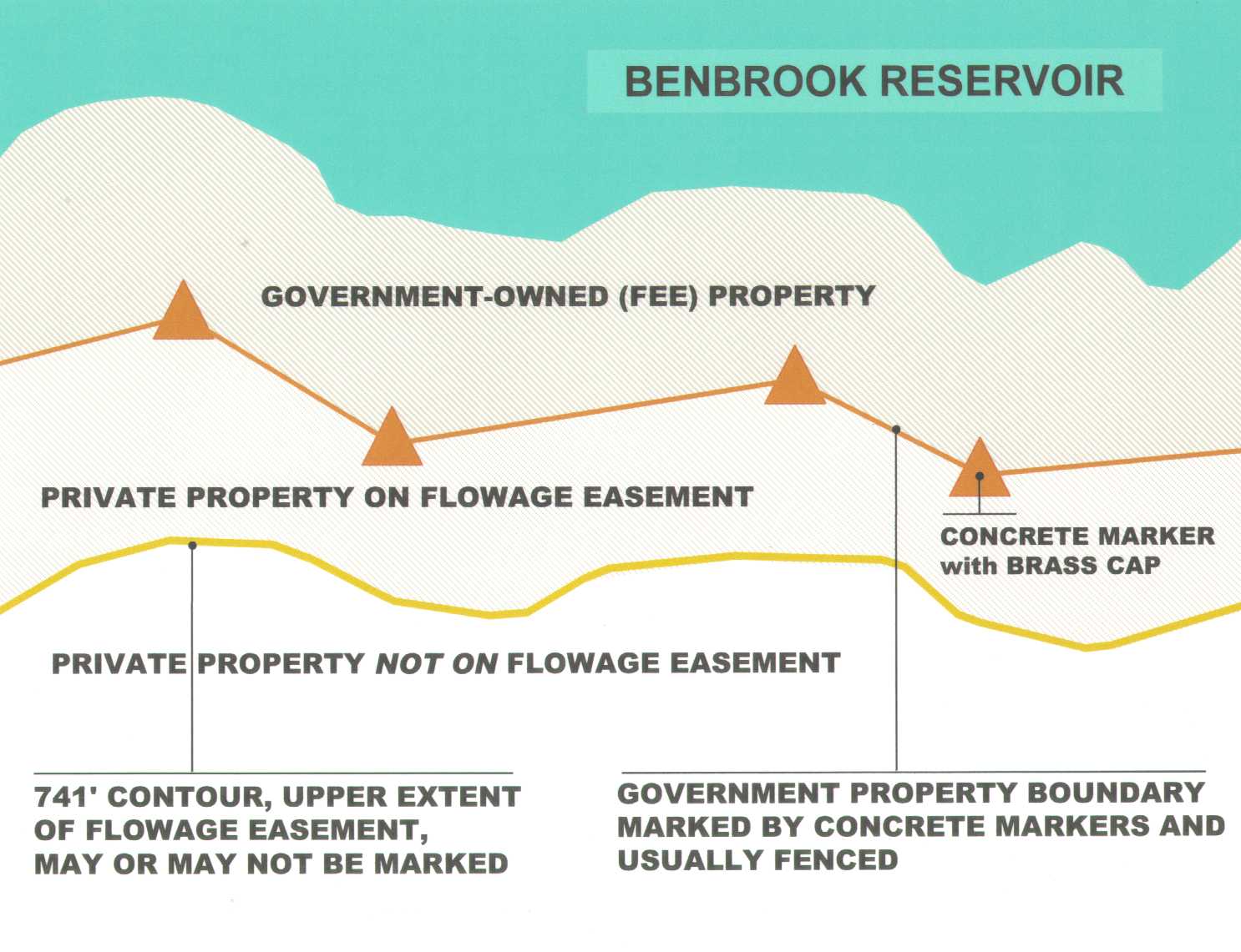
Government Owned (Public) Land
Land which is owned in fee by the government consists of both the land where Benbrook Lake is located and the surrounding property. The limits of this public land are defined by the U.S. boundary line, the corners of which are marked by concrete monuments. The boundary markers or monuments are each topped with a bronze cap.
As an Adjacent Landowner, You May:
- Apply for a permit to mow or clear underbrush to reduce fire hazard or pest infestation. Upon inspection and approval, restrictions as to method of removal and types of vegetation to be removed will be included in the permit.
- Apply for a license to place waterline over Government property to the lake, and to withdraw water for private use. As with above, a prior written request must be made. Water rights must be obtained from the Trinity River Authority before approval will be granted.
- Construct a fence to or along the Government boundary line.
- Have unlimited pedestrian access to public land except those areas specifically restricted: Residents adjacent to parks must enter through the park gatehouse.Residents along Wildlife Management Areas should enter through a consolidated access point for the community, as approved by the lake office.
As an Adjacent Landowner, You May Not:
- Use public lands for any type of private exclusive use, or for commercial purposes.
- Place unattended personal property of any kind on public land.
- Construct buildings, roads, improved pathways, or any other facilities on public land.
- Restrict public access to public land either verbally, by posting signs, or by any other method.
- Operate vehicles on public land, except on paved roadways and at authorized access points.
- Dispose of any type of garbage, debris, or other refuse on public land.
- Camp on public land, except in designated areas.
- Have fires on public land except in authorized receptacles.
- Gather fallen timber for firewood except for use on public lands.
- Allow horses, cattle, or other livestock on public land except by lease from the Government or as otherwise permitted.
- Destroy, alter, or remove any facility, vegetation, natural or archaeological feature.
Requirements for Submitting Requests to Construct on Flowage Easement Lands
Introduction
This document provides an outline of information that is required for the U.S. Army Corps of Engineers to process a request to place a structure on, or alter the contour of, privately owned lands on which the Corps has obtained a flowage easement. This document will assist the private landowner to use their property and yet protect the government’s acquired interest. This document is specific to Benbrook Lake, Tarrant County, Texas.
Background
Flowage easements were purchased so that waters could occasionally overflow, flood and submerge the property.
Restrictions
Flowage easement grants to the Corps the right to protect the easement by prohibiting the landowner from taking any action that might injure or destroy the easement. Although provisions may vary in the individual flowage easement instrument, most include the following provisions:
- No structure for human habitation shall be constructed or maintained on the land.
A habitable structure is defined as any structure that could be used for human habitation. These structures would include, but are not limited to, houses, cabins, mobile homes, recreational vehicles, travel trailers, overnight campgrounds, etc. For the purpose of this document any structure that has a toilet facility will be considered habitable. This restriction would also preclude attaching garages, decks, and similar structures to a habitable structure that is located off of flowage easement.
- No other structure shall be constructed or maintained on the land except those that have been approved in writing by the Corps
- No excavation shall be conducted or fill placed on the land without Corps approval.
Methods of purchasing
Each deed should be read carefully to determine the method by which the Government acquired the flowage easement. The two most common methods by which flowage easements were purchased are described below:A metes and bounds description that indicates the controlling elevation: Regardless of the actual metes and bounds description, the provisions of the flowage easement apply only in the area at or below the specified controlling elevation. The owner of the underlying fee land may do with the land that lies above the specified controlling elevation as he wishes without interference or permission from the Government, even though the land may be within the metes and bounds description of the flowage easement.
- A metes and bounds description that does not specify a controlling elevation: Flowage easement restrictions apply to the area within the entire metes and bounds description regardless of the elevation. These restrictions include the right to prohibit human habitation, approve structures, and control fill.
Controlling elevation
It is the landowner’s responsibility to be aware of and locate the contour elevation for the flowage easement. Personnel at the local Corps lake office may be able to provide the landowner general assistance in locating the elevation.
Activities which do not require prior approval
The owner, without prior written approval of the District Engineer, may take the following actions involving flowage easement lands:- Subject to all conditions contained in the flowage easement instrument concerning human habitation, structures, etc., the owner of such land can lease or sell the land to others.
- Flowage easement land can be mowed or cleared. Vegetation may be planted as desired.
- Fences made of posts and wire or similar materials do not need prior approval. Fencing made of bricks, stone or similar materials will need prior approval.
Other structures or activities may be permitted with prior approval
-
Other structures
Other structures that require prior approval of the District Engineer include all structures of any kind and character, in, under, on or above the surface. Examples of structures which must be approved by the Corps include, but are not limited to, buildings, roads, ramps, ditches, channels, dams, dikes, wells, earthen fills, and all types of utility lines, (i.e., water, gas, electricity, sewage, etc.) Structures that have been previously approved by the Corps but are now not in compliance with the current policy will be grandfathered as long as the structure has not been structurally modified. Structural modifications would include enlarging the structure, changing roof lines, etc., but would not include maintenance such as painting or replacing roofs or siding. -
Excavations and fills
The Corps will generally not approve a proposal that would result in a loss of flood storage capacity. Any fill placed on the surface must be offset by an equal quantity of excavation or cut. The Lake Manager will determine if the no net loss of flood storage concept will be waived for specific requests. - When the flowage easement is described by a controlling elevation, fill may not be placed so that the land is raised above the flowage easement contour, or to relocate the controlling elevation contour.
- When no controlling elevation is stated, fill may not be placed so that the land is raised above what would have been the flowage easement contour if one had been referenced.
- Excavations must be performed so as not to adversely affect government-owned fee property. Excavated areas will be stabilized and maintained according to sound land management practices. Any excavated material disposed of off flowage easement shall be placed so it will not be re-deposited through erosion back onto the flowage easement area.
-
Examples of structures or activities usually considered appropriate on flowage easement
Landowners must obtain prior written approval from the Corps and structures shall be anchored or constructed to minimize damage during flooding:
- Free-standing gazebos, storage sheds, barns, picnic shelters, patios, decks, garages may be approved. Also stairways, sidewalks, swimming pools, hot tubs, utility lines (including water, electric, sewage), security lights, landscaping involving placement of structures and/or cut and fill, roads, driveways, satellite dishes, retaining walls, erosion control structures, fences (see paragraph 10.c), parking lots, ponds, oil and gas extraction structures, oil and gas lines, excavation and fills may be acceptable.
- Water wells may be drilled or dug provided the location and construction thereof meets all applicable laws, rules, regulations, and standards from the standpoint that no pollution of the water well or interference with operation of the reservoir project will result or occur therefrom. Wells must be located a minimum of 50 feet from any property line provided the well is located at the minimum horizontal distance from other sources of potential contamination as listed in 30 TAC 238.43. 30 TAC 238 also states that a well shall be located at a site not generally subject to flooding; provided, however, that if a well must be placed in a flood prone area, it shall be completed with a watertight sanitary well seal and steel casing extending a minimum of 36 inches above ground level.
- A concrete slab may be poured provided it is not to be used for attachment of a building or a mobile structure for human habitation and it is not attached to a habitable structure. Concrete will be considered fill as referenced in paragraph 9. Excavations and Fill.
- The owner may give easements or permits for utility lines after the District Engineer issues a "consent to easement" instrument to the utility company.
- Recreational courts (e.g. tennis, volleyball, baseball, football, and rodeo) golf courses and playgrounds may be constructed.
- Sewage systems must be designed to insure that no pollution of the reservoir waters or other objectionable effects will result therefrom, either from a health or project operational standpoint, before approval will be given for such construction.
- Specifically, in the case of requests for sewage and septic systems at Benbrook Lake, written approval from Tarrant County Health Department and/or the Texas Natural Resources Conservation Commission (TNRCC) must accompany the request to the District Engineer. TNRCC regulations require, in the case of Benbrook Lake, that all septic systems be located a minimum of seventy-five (75) feet in horizontal distance above the Benbrook Lake fifty-year flood frequency, which is the elevation contour 712.5 feet NGVD.
- Streets or roads may be built, as long they are not raised above the controlling elevation.
- Storm water outfall structures may be considered only if they are designed so that there is no negative impact on the adjacent fee lands.
- Stand-alone toilets may be approved if they are associated with a community or governmental park facility.
- Electric lines may be approved provided the cut off switch is located above the flowage easement contour line. The line shall be either buried or in compliance with the low sag requirements of the Corps of Engineers as stated in ER 1110-2-4401. For either fee or flowage easement lands which lie within the flood pool of the Benbrook Lake reservoir, these low sag or minimum clearances range from fifty-two (52) to sixty-nine (69) feet above the maximum flood control pool elevation of 710.0' NGVD.
Structures or activities that are prohibited on flowage easement
Structures will not be allowed on flowage easement that will have the potential to interfere with the purpose for which the easement was acquired. Examples of the type of facilities which will not be approved are:- Storage tanks for petroleum or hazardous products. Exception: Tanks no larger than 500 gallons used to store liquid petroleum (propane) for private residences may be allowed.
- Commercial type buildings including but not limited to gas stations, restaurants, stores, offices, maintenance buildings, convenience stores, etc.
Application requirements to place structures on flowage easement
All requests for construction or placement of any structure or facility on either Government land or flowage easement land must include as a minimum the following (3 copies of each):- Letter of application to include name, address and telephone of applicant.
- Description of the structure or activity requested. Provide the elevation of the proposed structure or activity and include design plans for the baseline and finished floor elevations of structural foundations.
- A map showing the location of the proposed action, elevations of the structure or activity, and the relationship with the government boundary line and the flowage easement controlling elevation.
- Identify any excavations and/or fill. There should be no net loss of flood storage capacity. Include calculations of the cut and fill.
- Other information as required for specific requests, e.g., electric line low sag height requirements, electrical service, sewage system requirements, anchorage systems, etc.
- Written approval from any other regulatory agencies necessary.
Please call this office at 817/292-2400 if you have additional questions or need further information or assistance.
Reservoir Manager
U.S. Army Corps of Engineers
Benbrook Lake Office
7001 Lakeside Drive
Fort Worth, TX 76132
Example of Easement and Fee Land