Fort Worth District
Lakes and Recreation Menu
Guadalupe Park and Trails
This is NOT the state park.
Currently this trail is open for usage. It is only closed at the trail head during busy days to prevent the area from being trashed out.
Some parts are under reconstruction due to erosion around the first bridge.
Please do NOT enter this area where the old bridge existed. The drop off is deep and dangerous.
This is part of the federal parks managed by USACE. The state park is on the Guadalupe River near US281, west of Canyon Lake. To find that park website, click on the park name here Guadalupe River State Park
Select a link to jump to the section of this page you wish to view. Each section describes a different part of Guadalupe Park and Trail. A map and several pictures related to the trail are below the description.

Click this link to go to the park information page.
These links will take you to the other trails guide pages.
Overlook Park Trail Hancock Trail Madrone Trail
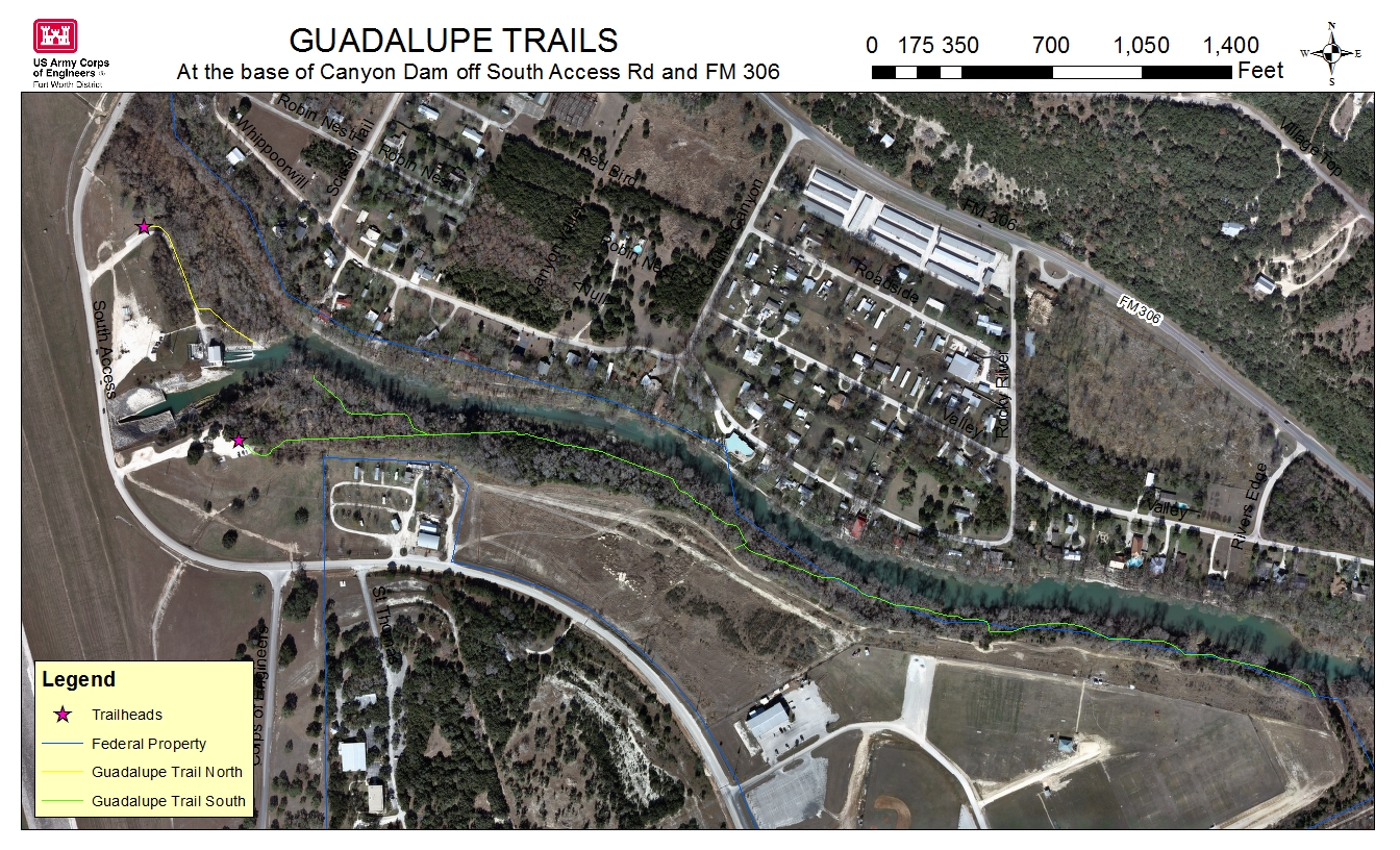
Park & Trail Images
Guadalupe North
Multipurpose Trail: ADA Accessible, Hiking and Fishing
This is a great fishing area especially during trout stocking season (Nov-Feb). However, the steep terrain of this area has historically limited its access to people with disabilities and physical limitations. This area is now accessible for most to enjoy. The Guadalupe North River Trail is a short, paved, fully ADA-accessible trail which leads from a North parking area to a concrete fishing platform at the mouth of the river.
The parking lot is located on South Access Road between FM 306 and FM 2673. It is the first parking lot on the left when coming off of FM 306.
The second parking lot is next to the power plant and has a long set of stairs for access to the fishing area.

Guadalupe South
Multipurpose Trail: Hiking, Fishing and Education
This trail area is maintained and cleaned by the local Lindheimer Chapter of the Texas Master Naturalist .
The trailhead is located at the base of Canyon Dam at the far end of the southernmost parking area. The trail is nearly a 1 mile long scenic walk along the bald cypress-lined banks of the Guadalupe River. This riparian trail along with the North River Trail, were built by volunteers during Public Lands Appreciation Day in 1995. Many of the trees along this trail are very large and believed to be over 100 years old.
We plan to continue to develop and lengthen the trail with help from the Texas Master Naturalist. If you or your group is interested in helping with trail building or trail maintenance, please contact the Texas Master Naturalist or our volunteer coordinator .
A guide for the self guided walking tour of the trail plants.

